When I did S216 (Environmental Science) I didn't do the associated summer school as I had the geology summer schools as my main focus. However with the decision of the Open University to end summer schools I decided to to take SXR216 - Environmental Science in the Field. Although I didn't quite realize it at the time, the August 1st presentation at Malham was the last presentation of the last year. The end of an era.
Day 0
 |
| Drift map of Malham Tarn area |
On the first evening we studied maps looking at both the geology and drainage patterns to give us a feel to the area.
Day 1
 |
| Oh grikey! |
The first day started with taking the weather readings from the Malham weather station. Following this we went for an orientation walk looking out for features we had discussed the night before. It was a 45 minute walk that took 5 hours (!). Our first stop was on an area of limestone pavement for which the Yorkshire Dales is famous. These are formed by complex interactions between climate and man. The horizontally-bedded carboniferous limestone is uplifted and develops cracks by pressure release. An advancing glacier scrapes away overburden and exposes the limestone, with subsequent glacial retreat leaving behind a flat, bare surface. Limestone is slightly soluble in water and especially in acid rain, so corrosive drainage along joints and cracks in the limestone can produce slabs called "clints" isolated by deep fissures called "grikes". The presence of indicator species of ancient woodland, such as harts tongue fern and dog's mercury, shows us that once the glaciers retreated the area became forested; the action of soils and plants on the cracks would make the grikes wider. This would take about 3000 years. By 7000 years ago the area would have been covered by an oak woodland. About 2.5-3.5 Kya in the late Neolithic to early Bronze Age the climate changed from a continental to an oceanic climate getting colder and wetter. This change together with the clearance of trees by Mesolithic peoples for agriculture results in the scenery we see today.
 |
| Watlows dry valley |
After walking down the hill we looked and described the view down Watlowes dry valley. As you can see in the photograph the valley has different topography at each side. Looking down the valley the left (SW facing) side shows a steeper V shaped profile with scree at the bottom while the right (NE facing) side shows a U shape. Originally this was a U shaped glacial valley but in the periglacial period the freeze-thaw cycles on the SW side have shattered the rock resulting in the scree and a steepening of the profile.
 |
| Water sink with river of OU students |
Further up there is an area of water sinks where the water drops from the surface into the complicated cave system typical of karst areas. Looking at the map it is easy to conclude that the water from here surfaces at the stream under Malham Cove but in limestone drainage is rarely that simple!
Around here we see the last outcrop of in situ limestone. The tarn sits on top of the impermeable Horton Formation (Silurian laminated hemipelagic silty mudstones) which as we can see from the geology map lies between 2 faults making it a horst.
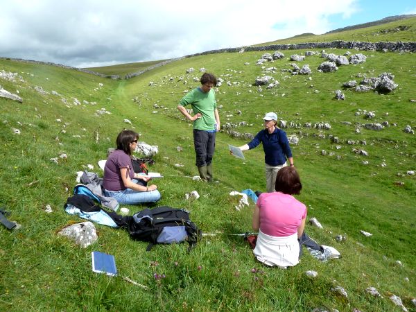
 |
| Phase 1 habitat survey |
After crossing the road we did a
Phase I Habitat survey of the area to the east of the tarn. Here we find a range of habitats which differ from the typical habitat of the area because of the geology. We mapped a large area of acidic grassland (B1.1) characterised by Nardus stricta (mat grass) and Galium saxatile (heath bedstraw). Our target note of bilberry suggests a possibility of regenerating heathland. There were patches of bog characterised as E3.2 (basin mire) and calcareous flushes (grass of parnassus, butterwort, bird's eye primrose and lesser clubmoss). We passed an area of shakeholes which often characterise the junction of the limestone and the harder rock. Near to a wall round a forested area we found some semi improved grassland (grazed and fertilized by animals) with more forbs (flowers!). Further round was another E3.2 marshy area (more of which later!) and some calcareous grassland. (
Target notes: 1. Bilberry; 2. Calcareous flushes - grass of parnassus, butterwort, bird's eye primrose and lesser clubmoss; 3. Acid grassland with patches of calcareous grassland)
Day 2
Today the groups split into 2 to do either water or soils. Our group did water. We collected pH, temperature and conductivity readings from 7 sites around the area. We also set up a soil conductivity experiment in the saturated mire to the west of the tarn and did some infiltration readings at Tarn Foot. After lunch we did flow measurements on Goredale Beck.
1. Cave fed stream
2. Cave fed stream
3. Confluence of 1 and 2
4. Lower dipwell
5. Upper dipwell
6. Tarn
8. Goredale beck
Temperature: The cave fed streams are cool (10 C) but warm slightly by confluence (12C). The tarn water is high (18.5 C) as it sits in a shallow lake absorbing heat. The peat bog absorbs heat so relatively warm (15 C lower, 17 C upper). Goredale beck is cave fed but has been heated (15 C)
Conductivity: Measuring Ca2+ at these locations. High in cave water (470 - 560 uS), low in bog (54-83 uS). Caves have picked up Ca2+ from limestone, bog is rain fed. Low at tarn outflow (89 uS) as calcium precipitates out as marl mud as plants use CO2.
pH: Cave fed between 7.3 and 8.3, bog 4 - 5 (pH of rainwater is 5). The tarn is alkaline (pH 8.5-9) - removal of CO2 from water removes carbonic acid so pH goes up.
We also did lots of flow stuff but quite frankly it doesn't interest me so I won't write it up.
Day 3
 |
| Rendzina, probably wouldn't go with a kebab |
What a difference a day makes, especially in North Yorkshire. After yesterday's brilliant sunshine today was a torrential downpour. Still the science had to go on so we took a wet walk up Fountains Fell to dig soil pits. Group number 1 (us) had to go to the top to dig a pit. The soil at the top is usually only 2-8 cm deep but after a bit of trying we found a deeper section (in a grike??) to take our samples from.
The soil at the top is a renzdzina, with an O horizon overlaying the limestone regolith.
At pit 2 we saw a poorly developed brown earth.
At pit 3 this has evolved into a podsol with a thick O horizon, an ashen A horizon and a permeable iron pan above the reddy coloured B horizon.
At pit 4 was a peaty gleyed podsol/stagno-gley podsol with a true (>20cm thick) peat horizon, a thick glayed A horizon, and impermeable iron pan and loess/limestone regolith at the bottom.
 |
| Robin and Hilary demonstrate synchronized augering |
Day 4
 |
| Estimating DOMIN values |
Today was vegetation survey day. Luckily it was sunny and warm as looking at plants in the rain is no fun (!). We were practicing looking at vegetation in a 2 x 2m quadrat which is standard for the National Vegetation Classification (NVC) survey for this vegetation type. There were 2 sites, one was a calcareous grassland and the other a boggy site with lots of different mosses. The survey records species which occur in the quadrat and % cover using a the DOMIN scale. Today we only looked at one quadrat each, but as there were 5 groups we then had the standard number for the NVC. As well as the DOMIN this looks at constancy, how many of the 5 quadrats a species is present in. To classify the habitat we look firstly for constant species and secondly at associate species to determine the sub-category.
In the evening we had a "pub quiz" (exam) on what we had learned so far. Then the celebrating began.
Days 5 and 6
 |
| Ha Mire |
Now we had the skills we had to apply them in the field. Not easy after the celebrations of the night before. Each group was given a site and taken for initial observations at 2 bamboo canes. We then had to use these to formulate a hypothesis and plan the experiments to test it. Our site was at Ha Mire and we decided to do an NVC, soil tests (pH and moisture) and later we tested water conductivity around the site. One team member and myself got the job of doing the NVC. Never have I hated plants, and especially grass, so much. The first day we did the upper site, but we missed the point and surveyed an area without the key species of thyme! The second day we did the mire which was much easier. After much manipulation and help we came up with classifications of GC10 for the upper site and M10 for the lower. The other team members did the other tests. I think we did alright in the end, despite only having 2 days plant spotting to help us!
At the end of day 5 we had a toast to commiserate the demise of SXR216. Although non of us would have gone again it is a shame that no other students will be able to share the experience. We got a copy of a DVD once used in the course - they won't be needing it any more. All in all it was an intense and brilliant week, with lots of interest on the course and the gossip it generated to keep us all amused throughout the week. Farewell SXR216, missing you already.


