Sunday 8 December 2013
Monday 8 August 2011
SXR216 - The Last Farewell
When I did S216 (Environmental Science) I didn't do the associated summer school as I had the geology summer schools as my main focus. However with the decision of the Open University to end summer schools I decided to to take SXR216 - Environmental Science in the Field. Although I didn't quite realize it at the time, the August 1st presentation at Malham was the last presentation of the last year. The end of an era.
Day 0
On the first evening we studied maps looking at both the geology and drainage patterns to give us a feel to the area.
Day 1
The first day started with taking the weather readings from the Malham weather station. Following this we went for an orientation walk looking out for features we had discussed the night before. It was a 45 minute walk that took 5 hours (!). Our first stop was on an area of limestone pavement for which the Yorkshire Dales is famous. These are formed by complex interactions between climate and man. The horizontally-bedded carboniferous limestone is uplifted and develops cracks by pressure release. An advancing glacier scrapes away overburden and exposes the limestone, with subsequent glacial retreat leaving behind a flat, bare surface. Limestone is slightly soluble in water and especially in acid rain, so corrosive drainage along joints and cracks in the limestone can produce slabs called "clints" isolated by deep fissures called "grikes". The presence of indicator species of ancient woodland, such as harts tongue fern and dog's mercury, shows us that once the glaciers retreated the area became forested; the action of soils and plants on the cracks would make the grikes wider. This would take about 3000 years. By 7000 years ago the area would have been covered by an oak woodland. About 2.5-3.5 Kya in the late Neolithic to early Bronze Age the climate changed from a continental to an oceanic climate getting colder and wetter. This change together with the clearance of trees by Mesolithic peoples for agriculture results in the scenery we see today.
After walking down the hill we looked and described the view down Watlowes dry valley. As you can see in the photograph the valley has different topography at each side. Looking down the valley the left (SW facing) side shows a steeper V shaped profile with scree at the bottom while the right (NE facing) side shows a U shape. Originally this was a U shaped glacial valley but in the periglacial period the freeze-thaw cycles on the SW side have shattered the rock resulting in the scree and a steepening of the profile.


Further up there is an area of water sinks where the water drops from the surface into the complicated cave system typical of karst areas. Looking at the map it is easy to conclude that the water from here surfaces at the stream under Malham Cove but in limestone drainage is rarely that simple!
Around here we see the last outcrop of in situ limestone. The tarn sits on top of the impermeable Horton Formation (Silurian laminated hemipelagic silty mudstones) which as we can see from the geology map lies between 2 faults making it a horst.
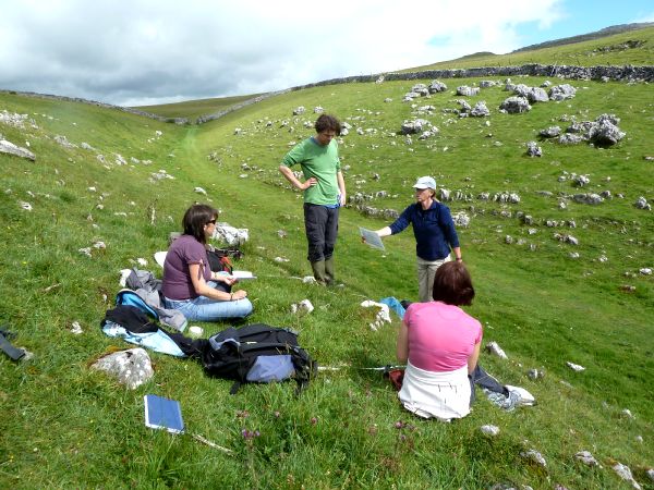
After crossing the road we did a Phase I Habitat survey of the area to the east of the tarn. Here we find a range of habitats which differ from the typical habitat of the area because of the geology. We mapped a large area of acidic grassland (B1.1) characterised by Nardus stricta (mat grass) and Galium saxatile (heath bedstraw). Our target note of bilberry suggests a possibility of regenerating heathland. There were patches of bog characterised as E3.2 (basin mire) and calcareous flushes (grass of parnassus, butterwort, bird's eye primrose and lesser clubmoss). We passed an area of shakeholes which often characterise the junction of the limestone and the harder rock. Near to a wall round a forested area we found some semi improved grassland (grazed and fertilized by animals) with more forbs (flowers!). Further round was another E3.2 marshy area (more of which later!) and some calcareous grassland. (Target notes: 1. Bilberry; 2. Calcareous flushes - grass of parnassus, butterwort, bird's eye primrose and lesser clubmoss; 3. Acid grassland with patches of calcareous grassland)
Day 2
 Today the groups split into 2 to do either water or soils. Our group did water. We collected pH, temperature and conductivity readings from 7 sites around the area. We also set up a soil conductivity experiment in the saturated mire to the west of the tarn and did some infiltration readings at Tarn Foot. After lunch we did flow measurements on Goredale Beck.
 1. Cave fed stream
2. Cave fed stream
3. Confluence of 1 and 2
4. Lower dipwell
5. Upper dipwell
6. Tarn
8. Goredale beck
Temperature: The cave fed streams are cool (10 C) but warm slightly by confluence (12C). The tarn water is high (18.5 C) as it sits in a shallow lake absorbing heat. The peat bog absorbs heat so relatively warm (15 C lower, 17 C upper). Goredale beck is cave fed but has been heated (15 C)
Conductivity: Measuring Ca2+ at these locations. High in cave water (470 - 560 uS), low in bog (54-83 uS). Caves have picked up Ca2+ from limestone, bog is rain fed. Low at tarn outflow (89 uS) as calcium precipitates out as marl mud as plants use CO2.
pH: Cave fed between 7.3 and 8.3, bog 4 - 5 (pH of rainwater is 5). The tarn is alkaline (pH 8.5-9) - removal of CO2 from water removes carbonic acid so pH goes up.
We also did lots of flow stuff but quite frankly it doesn't interest me so I won't write it up.
Day 3
What a difference a day makes, especially in North Yorkshire. After yesterday's brilliant sunshine today was a torrential downpour. Still the science had to go on so we took a wet walk up Fountains Fell to dig soil pits. Group number 1 (us) had to go to the top to dig a pit. The soil at the top is usually only 2-8 cm deep but after a bit of trying we found a deeper section (in a grike??) to take our samples from.
The soil at the top is a renzdzina, with an O horizon overlaying the limestone regolith.
At pit 2 we saw a poorly developed brown earth.
At pit 3 this has evolved into a podsol with a thick O horizon, an ashen A horizon and a permeable iron pan above the reddy coloured B horizon.
At pit 4 was a peaty gleyed podsol/stagno-gley podsol with a true (>20cm thick) peat horizon, a thick glayed A horizon, and impermeable iron pan and loess/limestone regolith at the bottom.
Day 4
Today was vegetation survey day. Luckily it was sunny and warm as looking at plants in the rain is no fun (!). We were practicing looking at vegetation in a 2 x 2m quadrat which is standard for the National Vegetation Classification (NVC) survey for this vegetation type. There were 2 sites, one was a calcareous grassland and the other a boggy site with lots of different mosses. The survey records species which occur in the quadrat and % cover using a the DOMIN scale. Today we only looked at one quadrat each, but as there were 5 groups we then had the standard number for the NVC. As well as the DOMIN this looks at constancy, how many of the 5 quadrats a species is present in. To classify the habitat we look firstly for constant species and secondly at associate species to determine the sub-category.
In the evening we had a "pub quiz" (exam) on what we had learned so far. Then the celebrating began.
Days 5 and 6
Now we had the skills we had to apply them in the field. Not easy after the celebrations of the night before. Each group was given a site and taken for initial observations at 2 bamboo canes. We then had to use these to formulate a hypothesis and plan the experiments to test it. Our site was at Ha Mire and we decided to do an NVC, soil tests (pH and moisture) and later we tested water conductivity around the site. One team member and myself got the job of doing the NVC. Never have I hated plants, and especially grass, so much. The first day we did the upper site, but we missed the point and surveyed an area without the key species of thyme! The second day we did the mire which was much easier. After much manipulation and help we came up with classifications of GC10 for the upper site and M10 for the lower. The other team members did the other tests. I think we did alright in the end, despite only having 2 days plant spotting to help us!
At the end of day 5 we had a toast to commiserate the demise of SXR216. Although non of us would have gone again it is a shame that no other students will be able to share the experience. We got a copy of a DVD once used in the course - they won't be needing it any more. All in all it was an intense and brilliant week, with lots of interest on the course and the gossip it generated to keep us all amused throughout the week. Farewell SXR216, missing you already.
Day 0
 |
| Drift map of Malham Tarn area |
Day 1
 |
| Oh grikey! |
 |
| Watlows dry valley |


 |
| Water sink with river of OU students |
Around here we see the last outcrop of in situ limestone. The tarn sits on top of the impermeable Horton Formation (Silurian laminated hemipelagic silty mudstones) which as we can see from the geology map lies between 2 faults making it a horst.
 |
| Phase 1 habitat survey |
Day 2


2. Cave fed stream
3. Confluence of 1 and 2
4. Lower dipwell
5. Upper dipwell
6. Tarn
8. Goredale beck
Temperature: The cave fed streams are cool (10 C) but warm slightly by confluence (12C). The tarn water is high (18.5 C) as it sits in a shallow lake absorbing heat. The peat bog absorbs heat so relatively warm (15 C lower, 17 C upper). Goredale beck is cave fed but has been heated (15 C)
Conductivity: Measuring Ca2+ at these locations. High in cave water (470 - 560 uS), low in bog (54-83 uS). Caves have picked up Ca2+ from limestone, bog is rain fed. Low at tarn outflow (89 uS) as calcium precipitates out as marl mud as plants use CO2.
pH: Cave fed between 7.3 and 8.3, bog 4 - 5 (pH of rainwater is 5). The tarn is alkaline (pH 8.5-9) - removal of CO2 from water removes carbonic acid so pH goes up.
We also did lots of flow stuff but quite frankly it doesn't interest me so I won't write it up.
Day 3
 |
| Rendzina, probably wouldn't go with a kebab |
The soil at the top is a renzdzina, with an O horizon overlaying the limestone regolith.
At pit 2 we saw a poorly developed brown earth.
At pit 3 this has evolved into a podsol with a thick O horizon, an ashen A horizon and a permeable iron pan above the reddy coloured B horizon.
At pit 4 was a peaty gleyed podsol/stagno-gley podsol with a true (>20cm thick) peat horizon, a thick glayed A horizon, and impermeable iron pan and loess/limestone regolith at the bottom.
 |
| Robin and Hilary demonstrate synchronized augering |
Day 4
 |
| Estimating DOMIN values |
In the evening we had a "pub quiz" (exam) on what we had learned so far. Then the celebrating began.
Days 5 and 6
 |
| Ha Mire |
Now we had the skills we had to apply them in the field. Not easy after the celebrations of the night before. Each group was given a site and taken for initial observations at 2 bamboo canes. We then had to use these to formulate a hypothesis and plan the experiments to test it. Our site was at Ha Mire and we decided to do an NVC, soil tests (pH and moisture) and later we tested water conductivity around the site. One team member and myself got the job of doing the NVC. Never have I hated plants, and especially grass, so much. The first day we did the upper site, but we missed the point and surveyed an area without the key species of thyme! The second day we did the mire which was much easier. After much manipulation and help we came up with classifications of GC10 for the upper site and M10 for the lower. The other team members did the other tests. I think we did alright in the end, despite only having 2 days plant spotting to help us!
At the end of day 5 we had a toast to commiserate the demise of SXR216. Although non of us would have gone again it is a shame that no other students will be able to share the experience. We got a copy of a DVD once used in the course - they won't be needing it any more. All in all it was an intense and brilliant week, with lots of interest on the course and the gossip it generated to keep us all amused throughout the week. Farewell SXR216, missing you already.
Saturday 10 July 2010
SXR339
GLEN GAIRN: NJ 294 008

Locality 1 Low-angled slabs beside road
• Pale medium grained granite
• Joints
Locality 2 Flat exposures near tree line
• Pinker granite (more alkali feldspar)
• Blob like pegmatite – feldspar crystals up to 6cm (gas rich magma has fewer nucleation sites leading to larger crystals)
Locality 4 Exposures near birch and pine trees
• Metamorphosed dalradian sediments with foliation (schist). Folded.
• Sharp contact with granite
• No chilled margins or baked edges – intruded at depth (not a big temperature difference)
• Evidence of other magmatic rock types (diorite, feldsite)
Locality 3 Crags west of Little Craig
• Coarser grained, biotite poor granite
• Sharp contact with sediments
• Huge pegmatite block

WOLVES ROCK – Above Kindrogan field centre
• Large fallen block of Pitlochry schist with garnets (2 - 4 mm) [garnet mica schist]
• Well defined depositional layers. Strong foliation – larger, redder garnets, weaker foliation – smaller oranger garnets (less Fe)
• Foliation around garnets (pre or syn kinematic)
NIGG BAY: NJ 965 049

Going away from carpark
Locality 1
• 50:50 mix of granite and schist
• Migmatite
• Granite oozing out of foliation in schist
• Horizontal foliation in schist
• Granite produced by crustal melting (20-30% to release granite)
Locality 2
• Medium grained granite (pink)
• Less granite than before
• Foliations more random
Locality 3
• 90:10 granite:schist
• Granite with small blocks of country rock in random orientation
• Fine to medium grained granite
Locality 4
• Amphibolite
• Sharp contact with granite
• Boudinaged quartz

DUNKELD

• Fold with axial cleavage
• Beds visible
• Antiform
• Younging direction towards centre so downwards facing and at least 2 stages of deformation
• Other synforms and antiforms visible
STONEHAVEN: Perthumie Bay NO 884 877; Garron Point NO 894 877.

Garron point
• Pillow lava
• Highland boundary fault
Skatie shore
• Rocks show bedding (steeper 80°) and cleavage (60°)
• Metapsamite
• Fine to medium grained sand
• Fining upwards
• Some flute marks
• Beds right way up

STRATH FIONAN: NN 717 575

Day 1
Locality 1
• Quartzite
• Elongated quartz grains
• Long tabular feldspar crystals
• Linear fabric
• Bedding (cross stratification)
Locality 9
• Schist
• Garnet
• Stautolite
• Kyanite (did not see)
• Crenulation lineation
Locality 6
• Large (10mm) garnets in sheet associated with quartz
• Garnet mica schist
• Garnet pre or syn kinematic
• No convincing boudinaged garnet
• V. good crenulation

Locality 4
• Kyanite??
Locality 3
• Amphibolite
• White plagioclase crystals
• Hornblend

Day 2
Locality 11
• Schist
• Garnet – pre or syn kinematic (eye structures)
• Kyanite (convincing) random orientation (cutting fabric)
• Amphibolite with long tabular plagioclase
• Sharp contact with schist
• Weathering proud
Locality 10
• Metamorphosed limestone
• Isoclinal folds
• Folds follow bedding
• S- and Z- folds
• Small outcrop of schist between limestone and dyke
• Sharp contact between amphibolite dyke and schist
• Garnets in amphibolite

Conclusion
• Planar fabric – schist only
• Linear fabric – schist (crenulation), quartzite (quartz and feldspar) and amphibolite (feldspar)
• No fabric – limestone
• All locations in kyanite zone but chemistry not always suitable to produce metamorphic minerals (eg kyanite needs Al)
Saturday 22 July 2006
SXR260 - The Geological History of the British Isles
Didn't we have a lovely time, the week we went to Durham?
Day 0 - Arrival and maps
 This year the SXR260 Summer School was based at Trevelyan College in Durham because St Mary's which was a women only college was letting men in (or going bisexual as Colin put it). After arrival and registration, we had for an introductory lecture and then off to meet our tutor groups. I was in group 4 with Colin as our tutor. (Colin was also the coach leader and his fine entertainment was yet another highlight of the week!) We were working in pairs within our groups, but as the last person in our group did not turn up I worked with Rob and Roger who kindly let me join them. We looked at the Lake District sheet and then at the larger scale Brough sheet. We were looking at the faults we would see later in the week, and discussing the Alston and Askrigg blocks that would be another large feature of the week. We also had a demonstration of how to use a compass clinometer and tried it out on a piece of sloping board in the lab. This year the SXR260 Summer School was based at Trevelyan College in Durham because St Mary's which was a women only college was letting men in (or going bisexual as Colin put it). After arrival and registration, we had for an introductory lecture and then off to meet our tutor groups. I was in group 4 with Colin as our tutor. (Colin was also the coach leader and his fine entertainment was yet another highlight of the week!) We were working in pairs within our groups, but as the last person in our group did not turn up I worked with Rob and Roger who kindly let me join them. We looked at the Lake District sheet and then at the larger scale Brough sheet. We were looking at the faults we would see later in the week, and discussing the Alston and Askrigg blocks that would be another large feature of the week. We also had a demonstration of how to use a compass clinometer and tried it out on a piece of sloping board in the lab. |
| Our first stop on day 1 was in the town of Barnard Castle. We were looking at an outcrop under the castle. This was our first go of the week at looking at rocks and sketching what we saw. We quickly established that it was a sandstone with evidence of water transport (no frosting, sub angular grains). There was cross bedding and channelling present. We also saw Raby castle and had our first mention of Lord Barnard. He would become a constant feature of our week's entertainment with Colin. |

|
| ||||
|


Five of us including Colin formed the team 'Gneissly Schist' for the pub quiz. Thanks to Colin we came second (but were leading for quite a while) and won some quite stunning quartz. Still, it could have been a plastic fossil...
View showing flat topped Wildboar fell on left (Askrigg block) and rounded Howgill fells on right (lake district block).
 |
| View showing flat topped Wildboar fell on left (Askrigg block) and rounded Howgill fells on right (lake district block) |
Day 2 - Whin Sill and Waterfalls
Day 2 was a day of two halves, igneous and sedimentary. Our first stop (apart from to look at the view) was at low force. Apart from the stunning waterfalls (formed of course by the water going over a more resistant rock type), we were looking at the structure of the Whin Sill. We started by looking at the polygonal forms of the columns formed when the magma cooled. Next we looked for the chilled margin at the top of the sill, which was rather elusive. After our photo stop by the sheep, we went to the second locality which was an outcrop of sill on top of bedded country rock. This was not the bottom of the sill but either a raft or pendant of country rock within the sill. The chilled margin here was much more evident. We looked at the lithology of the Whin Sill in the Whin Sill quarry. The main Whin Sill rock is dolerite (Bagshaw's Law: if you can see the grains, it's not fine grained!), but we also saw a pegmatite band formed from the last magma to cool - by this stage it is more hydrous allowing the more mobile molecules to form much larger crystals. We continued on the coach to High Force where we saw the actual bottom of the sill (in fact Colin is holding it up!) and the structure at the waterfall where, despite appearances, the sill sits on top of mudstone with limestone underneath. There were nice fossil corals in the limestone. After lunch (and a half of Cauldron’s Snout) it was time to look at sedimentary rocks at Bowlees. We worked our way up the river noting the rock types, faults etc. This is one of the Yoredale cyclotherms. Throughout the day we had various tales of Lord and Lady Barnard, including why most of the houses in these parts are painted white (I know you will be dying to know so I better tell you that these are the one's that Lord Barnard owns).
|
| ||||
|
| ||||
|
| ||||
|
|


Day 3 - Road, Quarry, Quarry, Quarry
Day 3 was the earliest start and latest finish of all our trips. Our first stop was the side of the A6 (overlooking the M6) at Tebay. We were here to study the structures in the Silurian rocks. We sketched the synclines, anticlines and faults (including a reverse fault), looked at the turbidites, saw fold slickensides and drags, tension cracks and flute casts. The peace and quiet at Shap Wells was welcome after all the noise. Here we saw steeply dipping Silurian rocks (with imaginary graptolytes) overlaid by early Carboniferous breccia containing pink orthoclase feldspar and clasts of weathered Shap granite (the Shap Wells unconformity). Lunch was eaten in the sunshine looking at this fabulous view. The granite plaques on the side of the Shap Wells hotel gave us a preview of what we would see later - and a plaque commemorating 25 years of OU visits. The red (or pink) Shap quarry did not disappoint. The large pink orthoclase phenocrysts were fantastic to behold, the simple twinning glinting in the sun. We studied the black enclaves of magma of a different composition that had been intruded into the main magma - orthoclase crystals from within the main magma have occasionally drifted into the enclave. The path up to the quarry was littered with rocks from the blue quarry - andesite with epidote, garnet, chalcopyrite and calcite making it a feast for the eyes. Off to our next quarry, Bongate Scar. This was a quarry for the local Brokram stone which is a very poorly sorted breccia or conglomerate (or even breccioconglomerate). There were thick fining up beds and channels as well as evidence of imbrication. This was an area of flash flooding at the edge of a desert (like areas of Death Valley today). Our final quarry of the day (Hoff) was medium grained, well sorted, well rounded frosted quartz with occasional feldspar leading to our conclusion of an aeolian origin. It showed massive cross bedding indicating dunes (in fact barchan dunes). Today's story was all about Little Musgrave and his 'partnering' with Lady Barnard...
|

Subscribe to:
Posts (Atom)